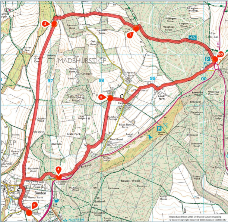
1. Start to Trot Row
Standing in the Whiteways car park with your back to the vehicle entrance and the Whiteways Cafe across to the left, walk at 1 o’clock to join the signed public bridleway leading you through a red gateway and into the woodland. Keep straight ahead on the main bridleway through the trees, ignoring any side paths. Further along you will pass the Forestry Commission sign, marking the start of Houghton Forest.
Some way further along, just a few metres after passing another public bridleway board, you will come to a fork with a way marker post on the left. Take the left-hand branch, following the blue arrows which mark the public bridleway. Shortly you will come to a crossroads, keep straight ahead on the bridleway which soon begins to climb through the trees.
Eventually you will emerge to a staggered T-junction, marked with a fingerpost. Bear right, staying with the main grass track, part of the Monarch’s Way. After 250 metres, look out for a (partially hidden) fingerpost on the left, marking a side path. Turn left here, follow the path through a short section of trees and to the edge of a large open field (an area called Trot Row).
2. Trot Row to Great Down
Turn right, following the track along the edge of the trees, on through a pretty section of mainly coppiced woodland. As you emerge from the trees, you will come to the edge of a large open crop field. Follow the grass track, diagonally left (at about 10 o’clock) across the centre of the field. Stay with this grass track, passing a section of woodland on the left and leading you to a signed crossroads of bridleways.
Go straight ahead to join the track with open fields to the right and woodland to the left. You will come to a grass clearing in front of you. Walk through the centre of this clearing, passing immediately to the left of the two large pine trees and then steadily climbing. At the end of the clearing, you will come to a fork. Take the left hand branch, signed as the bridleway, leading you through a section of coppiced hazel.
At the top, turn right onto the field-side grass track and follow it as it swings left, leading you into the next woodland. A few metres in you will reach a T-junction with a track. Turn left and you will come to the gate at the top of Great Down.
3. Great Down to Slindon Forge
Pass through the gate (NOTE: you may find sheep grazing from this point) and take the grass path at 1 o’clock, leading you across the centre of the hillside. At the bottom of the first stretch, pass through the two gates in quick succession and continue down through the lower half of Great Down. At the end of Great Down, you will come to a line of trees and a fingerpost marking a junction. Go straight ahead on the bridleway, pass through the next gate, and follow the obvious grass path across the centre of Little Down.
At the end, pass through the gate to reach a staggered T-junction marked with a fingerpost. Take the path at 11 o’clock, passing a circular copse immediately on your right and then continuing uphill in the same direction into a tunnel of trees. Ignore the path into the field on the left, simply keep ahead on the tree-lined path. Further along, the track leads you alongside a fenced field on your right and then on past double gates to reach the road, Mill Lane, at the edge of Slindon Village.
Walk straight ahead down the narrow road, taking care of any traffic, to reach a T-junction. Turn left and follow the road as it swings right to become School Hill (with Old School House on the right). Pass Gaston Farm on the left. Soon you will see the junction with Church Hill off to the right. Ignore this, simply keep straight ahead. Continue downhill past the horse paddocks. Where the pavement ends, cross to the right-hand road edge and continue along the narrow section of road (taking care of any traffic). Stay on the main road as it bends left and a little further along you will reach The Forge.
4. Slindon Forge to Chichester Lodge
When you are ready to continue, retrace your steps back uphill through the village, passing Gaston Farm on your right. At the top of the hill (just after Old School House), swing left and then turn right into Mill Lane. As you approach the double gates from which you emerged earlier, you have two choices. If you want to avoid any stiles and dairy cattle, keep ahead and retrace your route back the way you came. Alternatively, if you want to complete the full circuit (stiles and cattle included) then follow the road as it swings right.
After 300 metres (just before the lane enters a tunnel of trees), turn left into the woodland, signed as a public footpath. A few paces in, take the right-hand branch at the fork and follow this narrow footpath through the woodland (which can get a little overgrown at times). At the crossroads (marked with a fingerpost) go straight ahead and you will emerge to a T-junction with a wider woodland track. Turn left along this and it will lead you to a T-junction with a tarmac access lane, with the pretty flint property, Chichester Lodge, on your right.
5. Chichester Lodge to New Barn Farm
Turn left along the tarmac access lane, following it steadily downhill between fenced fields. The lane swings steadily left with a section of woodland on the right. As soon as the woodland on the right ends, turn right by a disused stile following a field-edge path with the woodland still running on your right.
When the woodland ends, keep ahead for just a few more metres to reach a T-junction with a stone vehicle track. Turn left for just 30 metres and then turn sharp right to join another track which swings steadily left around a circular copse. Part way round, leave the path directly alongside the copse, forking right to follow a track across the centre of the crop field, to reach a gap into woodland ahead.
Follow the track through the woods and you will come to a stile ahead. NOTE: You are likely to come across dairy cattle within this long field. Cross the stile, ignore the path to the right, simply follow the main track ahead, a grass avenue pasture between lines of trees. At the top of the field, pass through the gate and follow the concrete track up to the crossroads alongside New Barn Farm.
6. New Barn Farm to End
Turn right onto another concrete track, with a line of trees running on the right. You will emerge to a T-junction with a country lane. Turn right and follow the lane as it swings left. Where the road swings right, keep ahead on the stone track for a few paces and then turn left on to the vehicle track leading you into woodland. Follow the main track ahead through the centre of the woods.
At the end, cross the stile ahead to enter the next cattle pasture. Walk at 1 o’clock to reach a stile and fingerpost on the opposite boundary. Cross the stile and you will emerge to a junction with a country lane. Turn right along the lane, taking care of any traffic, and it will lead you past a few cottages on your left and then past Lower Farm on your right.
Further along, the lane leads you into dense woodland, the southern part of Houghton Forest. Continue for about half a mile, climbing steadily for much of this (ignoring the signed bridleway into the woods and the vehicle entrance into the woods, both on the left). After half a mile, fork left onto the narrow grass path which leads you into a large grass clearing. Maintain your direction across this clearing and soon you will be able to see the red vehicle barrier within the Whiteways car park in the distance. Take the obvious grass path leading you to Whiteways, where the walk began.


